Rockhounding USA
: an informative and media-rich blog with articles, photos, videos, and maps to a wide variety of rock, mineral, fossil, and Indian artifact collecting sites across the USA.

Sunday, July 9, 2017

The Famous Fern Fossils of Pennsylvania


What rockhound hasn't gazed with geo-lust as they looked at photos of beautifully preserved fossil ferns? We seem to be "fond of fronds." (Okay, that was cheesy, but still accurate.) I remember, as a child, studying books and magazines with gorgeous, full-color images of various minerals, rocks, and fossils. The trilobites were fascinating, the colorful varieties of petrified wood were captivating, but there was always something magical about large plates of shale covered in delicately-preserved fossil ferns.


For decades I had heard about the famous fossilized ferns of Eastern Pennsylvania (Llewellyn Formation) and had dreamed of traveling there. The opportunity finally arrived during a family trip to visit our daughter in York, Maine.

As we traveled along Highway 80, a quick Google search made my heart nearly jump---we would pass just to the north of St. Clair, and St. Clair is home to the most sought-after fossil ferns in the world!


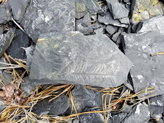
You have almost certainly seen photos of St. Clair fossil ferns. Due to the replacement of the organic material by pyrite (and then a subsequent oxidation process leading to Pyrophyllite) the fern and plant impressions are often a brilliant white set against the dark gray of the shale.

As my son, Chase, and I arrived at the huge collecting area, our expectations were more than exceeded. Nearly every piece of shale is covered in various types of plant remains, primarily ferns...it is a veritable fossil fern forest.

Here is a short video about this incredible collecting locale:


Directions:
*** NOTICE: I have recently read that the current owners have closed this area for individual collecting. Please contact the owners prior to visiting the site. The latest information I have found is that the owners are Reading Anthracite. They offer permits for off-road, ATV and hiking activities, but may not allow fossil collecting.***


Travel to St. Clair, Pennsylvania along Route 61 (Central Eastern Pennsylvania).
If you are headed North on 61, turn right onto E. Hancock (which becomes Burma Road), if you are headed south on 61, turn left onto E. Hancock. You will drive exactly 2.8 miles and there will be a small parking area on the right just before the road curves to the left and goes uphill.

(Caution: There is another parking lot on the right just before this spot. That parking area is for a gun shooting range. If you pull into the lot and see some boulders and then several wooden stands beyond the rocks, then you are in the wrong spot...you will need to travel about another 100 yards to the east.)

Park in the small, gravel lot, and take the smooth gravel hiking trail to the southeast for approximately 850 feet. Another trail will break off to the left, take it. You will need to hike about 1200 feet down this second trail until you see a small footpath through the bushes on your right. Go about 50 feet down this trail and the collecting area will open up before you. It is quite extensive. (Don't worry, even if you miss the second trail, if you hike all the way down the first trail you will eventually hit the lower, western end of the collecting area.)


Google Map location for the turn from Route 61 to E. Hancock:
https://www.google.com/maps/place/40%C2%B043'12.2%22N+76%C2%B011'35.4%22W/@40.7200556,-76.1941564,314m/data=!3m2!1e3!4b1!4m5!3m4!1s0x0:0x0!8m2!3d40.720058!4d-76.193159

Google Map location for parking area:
https://www.google.com/maps/place/40%C2%B044'24.9%22N+76%C2%B008'51.9%22W/@40.74025,-76.1495913,584m/data=!3m2!1e3!4b1!4m5!3m4!1s0x0:0x0!8m2!3d40.740253!4d-76.147737

Google Map location for Fern Fossil collecting area:
https://www.google.com/maps/place/40%C2%B044'20.8%22N+76%C2%B008'26.5%22W/@40.7391111,-76.1425009,573m/data=!3m2!1e3!4b1!4m5!3m4!1s0x0:0x0!8m2!3d40.739098!4d-76.140698


Head down this trail for 850 feet before turning left and hiking about 1200 feet:
Take this small trail off to the right for about 50 feet:


Collecting area:


Photos from the adventure:


Visit our Rockhounding USA Store. Find that perfect gift for any Rockhound or Prospector in your life!


Saturday, May 27, 2017

Resources for Identifying Arrowheads

If you want to study and identify insects, then you have a tough road ahead of you. I've read that there are over 350,000 different species of just Beetles (that's a quarter-of-a-million!). And if you want to collect and identify Native American Artifacts ("arrowheads"), the number of different types (though much smaller) is still pretty daunting: over 1,000.
One thousand different types of arrowheads, projectiles, points, blades, etc.
I only have THREE children and I still get their names wrong from time to time!

Fortunately, for those of us who enjoy walking along plowed fields and wading through waist-high creek water in search of these rocky links to our continent's past inhabitants, there are resources to help us. I have compiled a series of links to online resources that should be able to help you identify just about every tool or tip in your collection.


(1) What's the Point?
 

This simple to use and extremely helpful website contains a step-by-step guide that will ask you a series of basic questions (with pictures and diagrams) in order to zero-in on your classification. The number of arrowhead types is rather limited to just major categories, but I have found this to be very handy (and very kid-friendly).
(Click on the name or the picture to go to the website)


(2) Projectile Point Identification Guide
 

One of the largest online databases of Native American Artifacts, with thousands of reference photographs. This site breaks the USA into basic regions and contains a wealth of information about shape, flaking patterns, cross-sections, size, and age of every type of projectile and tool. I spend quite a bit of time here.


The name Overstreet is legendary within the world of collectibles. The Overstreet Indian Arrowhead Identification Database website boasts over 60,000 reference photographs and a (somewhat) guided tour to help you classify your points. You can search by Shape, Region, or Alphabetically. 


Sometimes, even with all of the wonderful online resources at our fingertips, we still have difficulty nailing the exact category or type of our tips. TreasureNet is a fantastic forum where you can post pictures of your artifacts, and then a huge community of Indian enthusiasts will pitch in to help you identify them.


Other Helpful Resources:


Arrowhead Timeline (great!)


Visit our Rockhounding USA Store. Find that perfect gift for any Rockhound or Prospector in your life!

Saturday, May 13, 2017

Arrowhead Chronicles: Episode One

I will never forget my first discovery of a Native American artifact: a long, multicolored jasper arrowhead that was sitting exposed atop a mound of dark soil in our neighbor's garden in the tiny, quiet town of Doniphan, Missouri. The year was 1980.

Unfortunately, that exquisitely carved and beautifully banded blade has been lost for at least the second time in its long life. I would love to have it back again. It would be another nine years before I would find my second Indian relic, this time time along the shores of the Little Gasconade River near Freeburg, Missouri. A small rise in the center of a long, muddy field yielded multiple arrowheads and scrapers, along with several chip piles. Due to the quantity of artifacts continually produced by each season's tilling and turning of the soil, it was obvious that the area had been a Native American campground for many years.
Artifacts from near the Little Gasconade River, Missouri

Fast forward nearly thirty more years. I am now not only a rockhound and relic collector, I am also a father. And I have done my best to impart my passion for geology and history to my offspring. My first two children (daughters) carefully avoided these pursuits, but my third child, Chase, has been bitten by the bug. He has joined me in the shale piles in Utah splitting for Trilobites and has sifted through hundreds of pounds of wet sand and gravel seeking for fossilized shark's teeth in the deep South. He has scratched through the rusty, iron and silica rich earth near Mt. Ida, Arkansas to acquire the finest quartz crystals in North America, and he has scaled the heights of the Colorado Rockies seeking for pyrite cubes strewn about in the tailings of abandoned mines.

But lately he has been bitten by a slightly different (yet related) bug: Arrowheads.

We've spent endless hours watching the antics of Randy and Spike over at the Heartbreaker Relics channel on Youtube, or the predictable "We'll get back to ya" closing line after each exciting find on the channel TheDitchWalker. My son lamented that he himself had never found an arrowhead.

That problem was resolved....today.


After receiving a hot tip about a productive site not quite 10 miles south of our home, we spent 2-1/2 hours traipsing through a huge, flat field that was still moist from a few days of steady rain and littered with the remains of short, shattered corn stalks and withered cobs. Within minutes of hitting the soil, Chase landed our first and his first-ever Indian find: a broken base. By the end of the short adventure, we had a nice little collection of blades, bases, tips, and one whole arrowhead.

Enjoy this 90-second video about our experience:


Visit our Rockhounding USA Store. Find that perfect gift for any Rockhound or Prospector in your life!

Crinoids, Bryozoans and More in Southern Illinois Roadcut


Looking west (north side of roadcut)
Almost exactly five miles east of Anna, Illinois, along Highway 146, a small rocky outcrop on the north side of the gentle incline yields a fair amount of ancient, aquatic fossils. Crinoids, shells, and Archimedes screws (bryozoans) abound, both having been weathered loose as well as in situ.


The layered outcrop on the north side shows the most promise, but the dirt covered exposure on the southern bank is worth digging through as well.

CLICK HERE for a Google Maps locator to this site


Visit our Rockhounding USA Store. Find that perfect gift for any Rockhound or Prospector in your life!

Sunday, April 16, 2017

Shark's Teeth in Central Mississippi

Having been raised along the sedimentary strata of coastal California near Santa Cruz, I was no stranger to fossilized shark teeth as a child. But, after relocating to the Midwest at the end of 1979, I feared that my ancient tooth hunting days might be over. And now, thirty-eight years later (with a rockhound-of-a-son about the same age I was when I moved) we took a little geological roadtrip to Alabama and then back up through Mississippi.


I stumbled across information about the W.M. Browning Cretaceous Park online a few months back. It seemed like a dream come true--fossilized shark's teeth in a modest creek only about four hours away from home. I was chomping at the bit, waiting for spring break so that Chase and I could hit some fossil hotspots across the South, especially excited to sift through the sandy gravels of  Twentymile Creek just north of Frankstown, Mississippi.

Looking to the West. Hwy 45 passes over
Mid-April arrived, and we packed up and headed down Interstate 55. We first traveled to Macon County, Alabama to hunt for petrified wood all afternoon on Friday near Wetumpka, and then jotted down to the coast for a Saturday of fun at the beach in Gulf Shores. On Sunday we traveled up Highway 45 to Starkville, Mississippi for Easter services with a friend, and then changed into our rockhounding water gear and hurried to the intersection of Highway 45 and County Road 7450.

Looking East (County Rd. 7450 bridge)
W.M. Browning Cretaceous Park (not really a "park" but rather a small, dirt parking area along Twentymile Creek on the east side of Highway 45) is announced by a tall, marble-like slab on the left side of the short entrance. The monolith describes the modern and ancient history of the area, which is open to the public for free digging and sifting.

We parked, changed into our river shoes, grabbed our floating sifter (constructed of 1/4" hardware cloth with a 2x4 frame, and foam zip-tied to two sides for buoyancy) and shovel, before hiking down the steep northern bank to the cozy creek.


Initially we traveled about twenty-five yards to the east (left) and did several test screens from the river bottom, but found nothing. Another fossil enthusiast came walking up from the west (right) and shared with us that he had better luck towards the west (between where we were and where Highway 45 passed high above the creek).

He showed us his finds for the day, which included several fairly large and complete teeth. My pulse quickened and my resolve renewed. Chase and I thanked him for the advice, and then we heeded it.

After several unsuccessful screen tests of the sandy gravel along the southern bank, we decided to test a few shovelfuls from the bottom of the (fairly warm) creek. One of our early shovel loads immediately yielded a gorgeous black tooth. Chase snagged it up with a yell before I could hardly even focus on it. We continued in the center of the creek, typically finding a tooth about every two or three screens of material. Occasionally we would be blessed to find two teeth in one screen. We relocated to various spots off to the west, going as far as the overpass, but returned to our initial "honey hole" and continued to reap the benefits.

After three hours of back-breaking shovel work (Chase said that his skills were better served running the sifter!) we climbed back up the bank and nabbed a hotel room in Corinth, about thirty minutes north. We laid out our treasures, roughly 30 teeth, with great satisfaction. Since returning home, Chase has repeatedly spoken of heading back to Twentymile Creek. It is thrilling to see my son get just as excited as I was at his age when I had the opportunity to sift for shark's teeth.

CLICK HERE for a Google Maps locator for this fossil site.


Here is a short video about my recent expedition to the W. M. Browning Cretaceous Park to hunt for Shark's Teeth fossils:


Visit our Rockhounding USA Store. Find that perfect gift for any Rockhound or Prospector in your life!


Friday, April 14, 2017

Alabama Petrified Wood Adventure

The Alabama air temperature may be acting like early summer in mid-April, but the chilly creek water is still acting more like the late winter. The shallow, gentle flows of the Uphapee (also known as the Chewacla Creek) in northern Macon County was the petrified wood destination for my son, Chase, and I. The sun was high in the sky, the temperature hovered in the mid-70s, and we brought sunscreen and high hopes to this fossil hotspot in the deep South.

After turning off Interstate 85 and heading north for about 500 yards, we pulled off on the east side of Alabama State Route 81 (just after crossing the bridge) and trudged along the bamboo-infested, sandy banks of the Uphapee. It was a bit of a challenge to find an easy way down to the water, but we forged our way across to the southern bank and then headed east along the sandy, gravel bars.

Our first thirty minutes of scouring the wide assortment of rounded rocks (many of them composed of thin layers that seem like petrified wood) yielded nothing conclusive. We pushed further east for about another 200 yards and I finally landed the largest single piece of petrified wood I have ever found.

The 11-inch chunk was just a dark discoloration submerged about 6-inches deep along the bottom of the creek. I grabbed it and yanked it up, and let out a bit of a shout.

My son, not to be outdone, scoured the shallows only a few feet away and produced his own hand-sized chunk.

After another hour of fruitless searching, which included examining the gray clay layers on either bank, I headed back west about 50 yards and spotted a nice piece jutting up right at the southern edge of a gravel-bar island. The texture and detail of the jagged fragment was stunning.

I would have loved to have hunted on the shores on either side, but the density of the woods and the unmarked stretches of private property quickly squelched that enterprise. Since this trip, I have discovered that many people bring long metal poles and plunge them into the soft silt of the creek bottom. Large pieces of petrified wood are often found buried in the mud. Having collected petrified wood in Arizona and Colorado, I am used to finding large quantities of smaller chunks scattered over a wide area, but it is puzzling to me why we didn't find lots of smaller, rounded pieces on the gravel bars. We spent about three hours total, and I only found one small chunk that might be petrified wood (that wasn't down in the water). The reputation of the area as being rich in petrified wood led me to believe that we would readily find lots of smaller pieces scattered about. That just wasn't the case.

I've heard that there is more wood (and some of it coated with small crystals) to be found on the western bank of the creek leading up to the dam in Wetumpka, but that locale will have to wait for a future trip.

The creek had discolored the exterior of our fossils to a dark brown (almost black) along with a deep green, but we soaked them in a bucket of water mixed with healthy doses of C.L.R. cleaner (readily found at Wal-Mart) and they cleaned up nicely.


Click on this link for a Google Maps marker to this exact hunting spot:


Visit our Rockhounding USA Store. Find that perfect gift for any Rockhound or Prospector in your life!