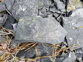
 What rockhound hasn't gazed with geo-lust as they looked at photos of beautifully preserved fossil ferns? We seem to be "fond of fronds." (Okay, that was cheesy, but still accurate.) I remember, as a child, studying books and magazines with gorgeous, full-color images of various minerals, rocks, and fossils. The trilobites were fascinating, the colorful varieties of petrified wood were captivating, but there was always something magical about large plates of shale covered in delicately-preserved fossil ferns.
For decades I had heard about the famous fossilized ferns of Eastern Pennsylvania (Llewellyn Formation) and had dreamed of traveling there. The opportunity finally arrived during a family trip to visit our daughter in York, Maine.
As we traveled along Highway 80, a quick Google search made my heart nearly jump---we would pass just to the north of St. Clair, and St. Clair is home to the most sought-after fossil ferns in the world!
You have almost certainly seen photos of St. Clair fossil ferns. Due to the replacement of the organic material by pyrite (and then a subsequent oxidation process leading to Pyrophyllite) the fern and plant impressions are often a brilliant white set against the dark gray of the shale.
As my son, Chase, and I arrived at the huge collecting area, our expectations were more than exceeded. Nearly every piece of shale is covered in various types of plant remains, primarily ferns...it is a veritable fossil fern forest.
Here is a short video about this incredible collecting locale:
Directions:
*** NOTICE: I have recently read that the current owners have closed this area for individual collecting. Please contact the owners prior to visiting the site. The latest information I have found is that the owners are Reading Anthracite. They offer permits for off-road, ATV and hiking activities, but may not allow fossil collecting.***
Travel to St. Clair, Pennsylvania along Route 61 (Central Eastern Pennsylvania).
If you are headed North on 61, turn right onto E. Hancock (which becomes Burma Road), if you are headed south on 61, turn left onto E. Hancock. You will drive exactly 2.8 miles and there will be a small parking area on the right just before the road curves to the left and goes uphill.
(Caution: There is another parking lot on the right just before this spot. That parking area is for a gun shooting range. If you pull into the lot and see some boulders and then several wooden stands beyond the rocks, then you are in the wrong spot...you will need to travel about another 100 yards to the east.)
Park in the small, gravel lot, and take the smooth gravel hiking trail to the southeast for approximately 850 feet. Another trail will break off to the left, take it. You will need to hike about 1200 feet down this second trail until you see a small footpath through the bushes on your right. Go about 50 feet down this trail and the collecting area will open up before you. It is quite extensive. (Don't worry, even if you miss the second trail, if you hike all the way down the first trail you will eventually hit the lower, western end of the collecting area.)
Google Map location for the turn from Route 61 to E. Hancock:
https://www.google.com/maps/place/40%C2%B043'12.2%22N+76%C2%B011'35.4%22W/@40.7200556,-76.1941564,314m/data=!3m2!1e3!4b1!4m5!3m4!1s0x0:0x0!8m2!3d40.720058!4d-76.193159
Google Map location for parking area:
https://www.google.com/maps/place/40%C2%B044'24.9%22N+76%C2%B008'51.9%22W/@40.74025,-76.1495913,584m/data=!3m2!1e3!4b1!4m5!3m4!1s0x0:0x0!8m2!3d40.740253!4d-76.147737
Google Map location for Fern Fossil collecting area:
https://www.google.com/maps/place/40%C2%B044'20.8%22N+76%C2%B008'26.5%22W/@40.7391111,-76.1425009,573m/data=!3m2!1e3!4b1!4m5!3m4!1s0x0:0x0!8m2!3d40.739098!4d-76.140698
Head down this trail for 850 feet before turning left and hiking about 1200 feet:
Take this small trail off to the right for about 50 feet:
Collecting area:
Visit our Rockhounding USA Store. Find that perfect gift for any Rockhound or Prospector in your life!


No comments:
Post a Comment