A collection of rockhounding and arrowhead (Indian artifact) field reports from across the nation. Join us for exciting geological and historical adventures involving rocks, minerals, crystals, fossils, and Native American artifacts as we include reports, photos, videos, maps and more. If you love rocks, minerals, fossils, and artifacts, then Rockhounding USA is your new home.
Rockhounding USA: an informative and media-rich blog with articles, photos, videos, and maps to a wide variety of rock, mineral, fossil, and Indian artifact collecting sites across the USA.
Watch this short video as we spend 60-seconds exploring everyone's favorite purple variety of quartz: Amethyst, right here on Mineral Minute:
Today’s Mineral: Amethyst
Amethyst is a colorful variety of the quartz family, often noted for its pale to deep shades of purple. Amethyst has a hardness of 7, no cleavage, a white streak, and a glassy luster. The famous hue of this mineral is caused by trace amounts of iron that are trapped inside the quartz lattice.
This iron is then further modified through different levels of radiation deep within the earth, producing a wide range of colors from reds to deep purple.
Amethyst is often found as large crystals, or in clusters, or within geodes at many famous deposits in Brazil, Uruguay, Mexico, Russia, Canada, and South Africa. Here in the United States, Amethyst can be collected at the: Emerald Hollow Mine in Hiddenite, North Carolina Diamond Hill Mine near Abbeville, South Carolina Amethyst Queen Mine near Nancy Hanks Gulch, Colorado Amos Cunningham Farm near Due West, South Carolina. and Jackson’s Crossroads Amethyst Mine near Jackson Crossroads, Georgia.
Note: All of these locations require permission and most require a fee for collecting.
If you visit most creeks in the southeast you are likely to find frogs, lizards, or even an occasional snake. But...SHARK'S TEETH? In this video episode, we travel to Frankstown, Mississippi in search of the remains of some of the best killers ever to swim the seas:
That beautiful pale blue to bluish-green member of the Beryl family, treasured by gem cutters and prized by mineral prospectors worldwide. What rockhound wouldn’t be thrilled beyond description to crack into a gaping pocket laced with dozens of long, unbroken, gem-quality aquamarine crystals still lodged perfectly atop a gorgeous matrix?
In the fall of 2004, that once-in-lifetime-thrill came to amateur prospector Steve Brancato, as he searched for topaz on the chilly, steep slopes of Mount Antero, the 10th highest peak in the state of Colorado. The high-school dropout turned fulltime gem hunter first extracted a loose 25-carat aquamarine, and that blue crystal became the first of many, many more over the course of the next few days. Brancato had uncovered the largest and most valuable pocket of aquamarine crystals ever unearthed in the United States. Once extracted and restored, the impressive slab measured roughly 3 feet by 2 feet, and was encrusted with dozens of aquamarine crystals rising alongside a forest of gorgeous smoky quartz points.
In a touching move in honor of his mother, Steve Brancato dubbed his incredible discovery “Diane’s Pocket.” As the biggest aquamarine cache ever found in the USA, its value is difficult to appraise, but some experts have estimated this one-of-a-kind wonder to be worth well over a million dollars.
“Diane’s Pocket” was first displayed publicly at the Tucson Gem and Mineral show in February of 2005, before being acquired by Bruce Oreck, a trustee of the Denver Museum of Nature and Science. Oreck then donated his spectacular purchase to the museum, where it has since been on continuous display for all the world to enjoy. The incredible, million-dollar discovery of Diane’s Pocket, another Amazing Tale of Geology brought to you by Rockhounding USA.
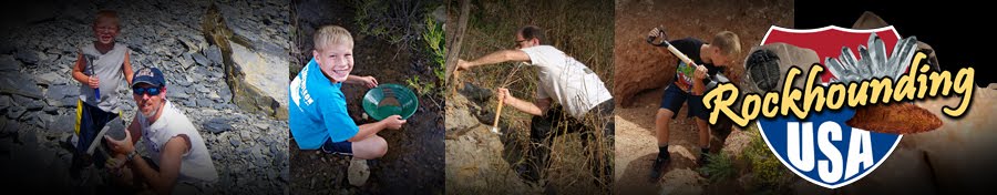
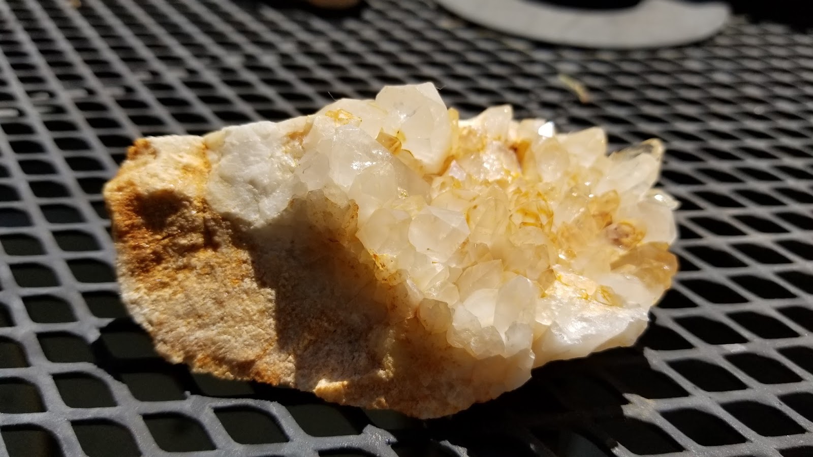
On this episode of Rockhounding USA, Chase and I travel to Mt. Ida, known as "The Quartz Crystal Capital of the World." We visit Judy's Crystals N Things before heading up Fisher Mountain to the Stanley Mine.We find hundreds of "float" crystals and track down the quartz veins that criss-cross the Ouachita Mountain range.
Here is a small collection of photos of our treasures:
Map to Judy's Crystals: https://www.google.com/maps/place/Judy's+Crystals+N+Things/@34.53085,-93.537886,15z/data=!4m2!3m1!1s0x0:0x87089268399c9d97?sa=X&ved=0ahUKEwjj9NCKgIrWAhWG24MKHbBWBZsQ_BIIeTAK
When you think of Diamonds...you think of the rich Kimberlite Pipes of South Africa.
But when you think of Herkimer Diamonds...you think of Herkimer County, New York.
On this installment of Rockhounding USA, we travel to the mines of Crystal Grove, about twenty miles east of Herkimer, New York, in search of those double-terminated treasures that await the seeker.
CLICK HERE for more Crystal Grove information. CLICK HERE for a Google Map to Crystal Grove.
Visit our Rockhounding USA Store. Find that perfect gift for any Rockhound or Prospector in your life!
I know, I know...the title of this blog article is a bit of an amazing amalgamation of alliteration, but, as I sit in this hotel room in Portsmouth, New Hampshire on a late morning, it's the best that I can do.
My faithful fellow rockhound-son, Chase, and I headed to Oxford County, Maine on a quest to the quarries of Frank Perham...in pursuit of the crystal pockets in the pegmatites of this mineralogically-rich region. I will be posting a longer field report in the next few days, but for now, enjoy PART ONE of this TWO-PART (eventually) video about our experience.
Visit our Rockhounding USA Store. Find that perfect gift for any Rockhound or Prospector in your life!
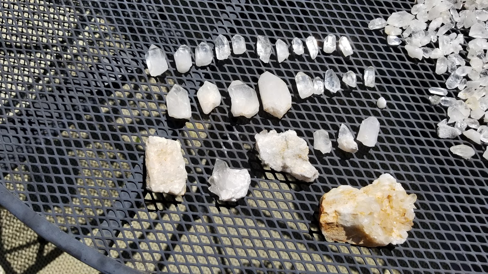
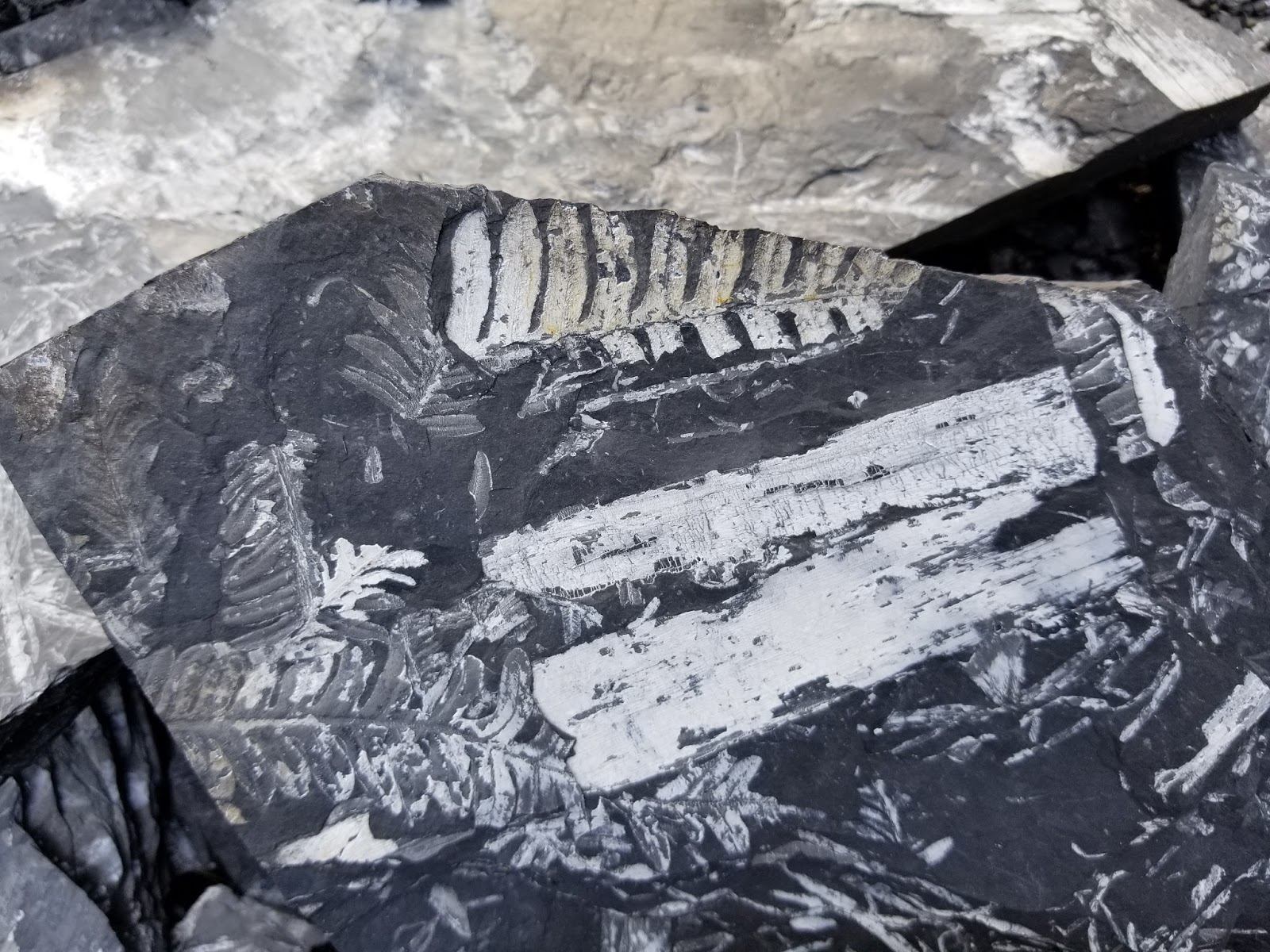
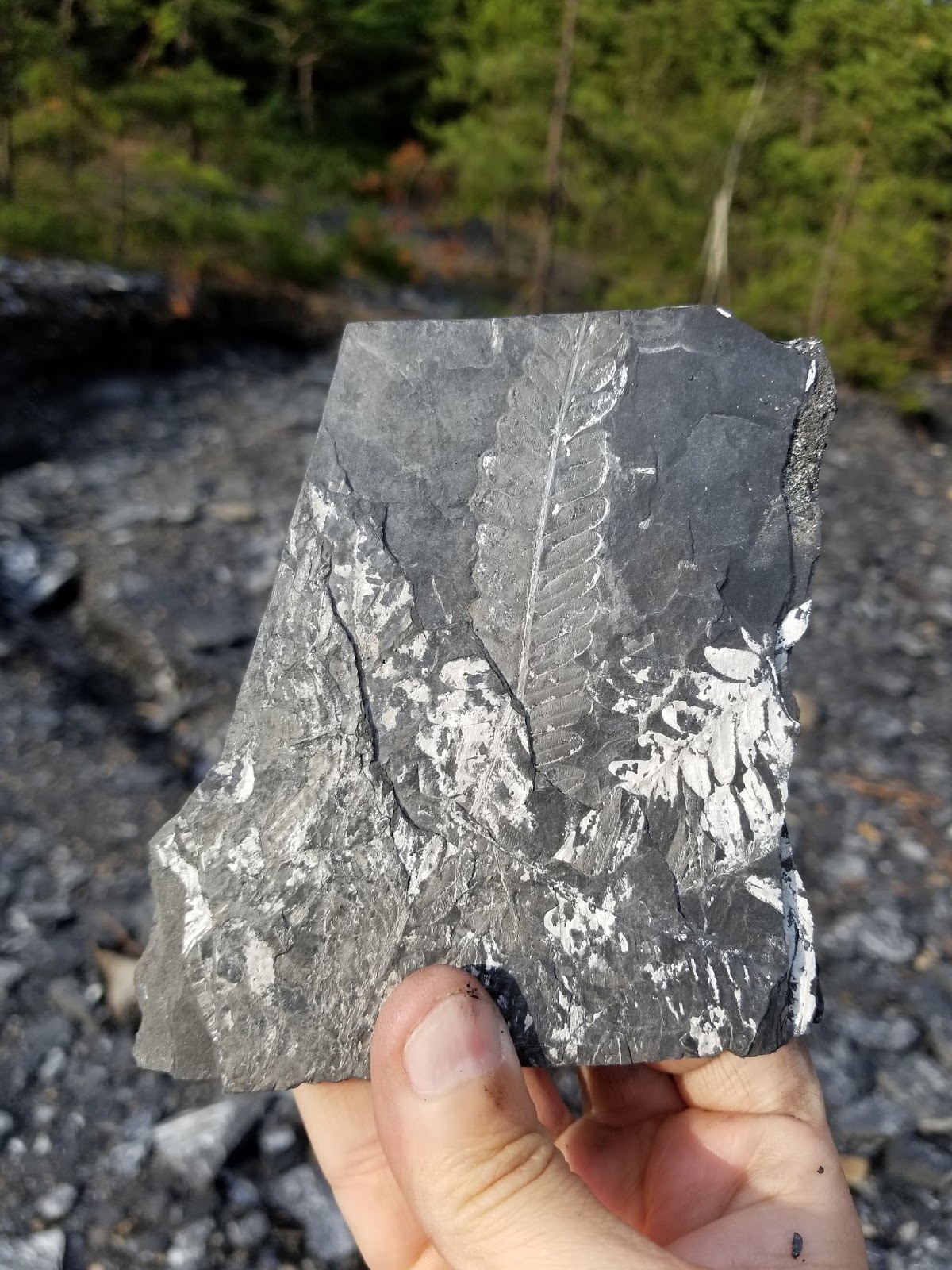
What rockhound hasn't gazed with geo-lust as they looked at photos of beautifully preserved fossil ferns? We seem to be "fond of fronds." (Okay, that was cheesy, but still accurate.) I remember, as a child, studying books and magazines with gorgeous, full-color images of various minerals, rocks, and fossils. The trilobites were fascinating, the colorful varieties of petrified wood were captivating, but there was always something magical about large plates of shale covered in delicately-preserved fossil ferns.
For decades I had heard about the famous fossilized ferns of Eastern Pennsylvania (Llewellyn Formation) and had dreamed of traveling there. The opportunity finally arrived during a family trip to visit our daughter in York, Maine.
As we traveled along Highway 80, a quick Google search made my heart nearly jump---we would pass just to the north of St. Clair, and St. Clair is home to the most sought-after fossil ferns in the world!
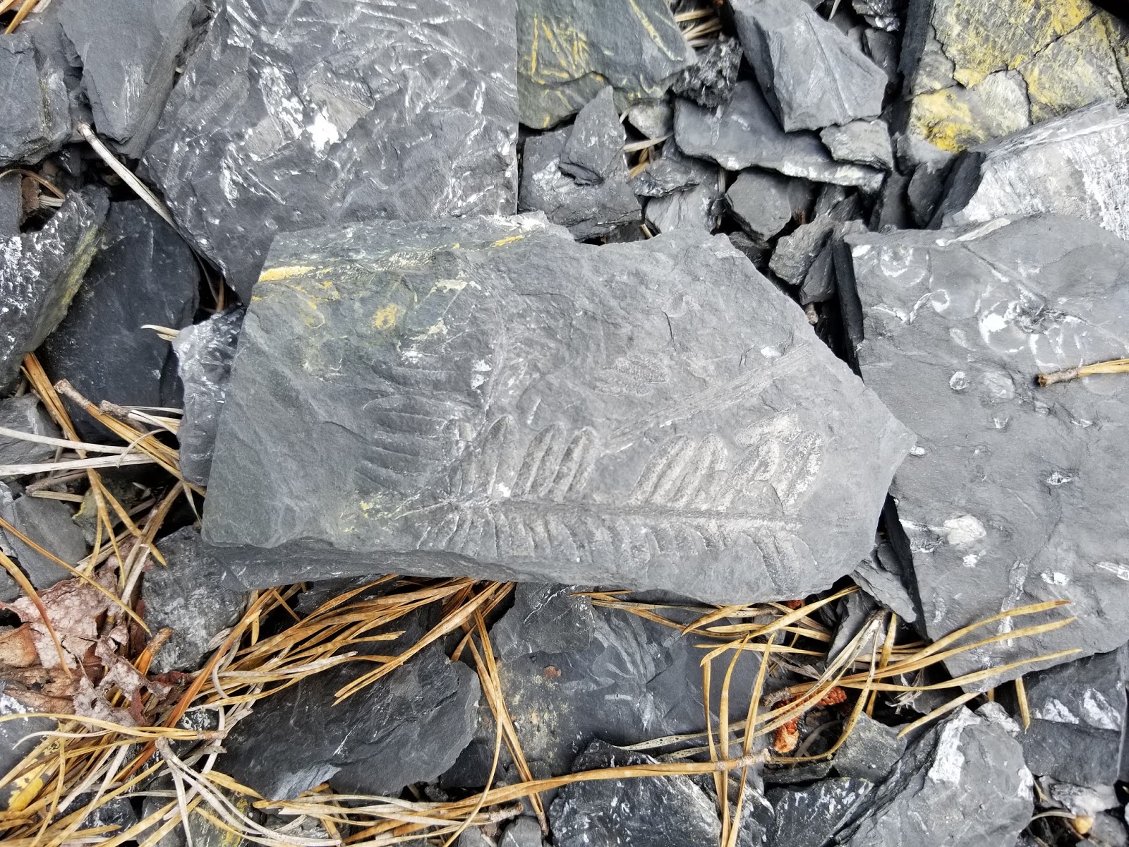
You have almost certainly seen photos of St. Clair fossil ferns. Due to the replacement of the organic material by pyrite (and then a subsequent oxidation process leading to Pyrophyllite) the fern and plant impressions are often a brilliant white set against the dark gray of the shale.
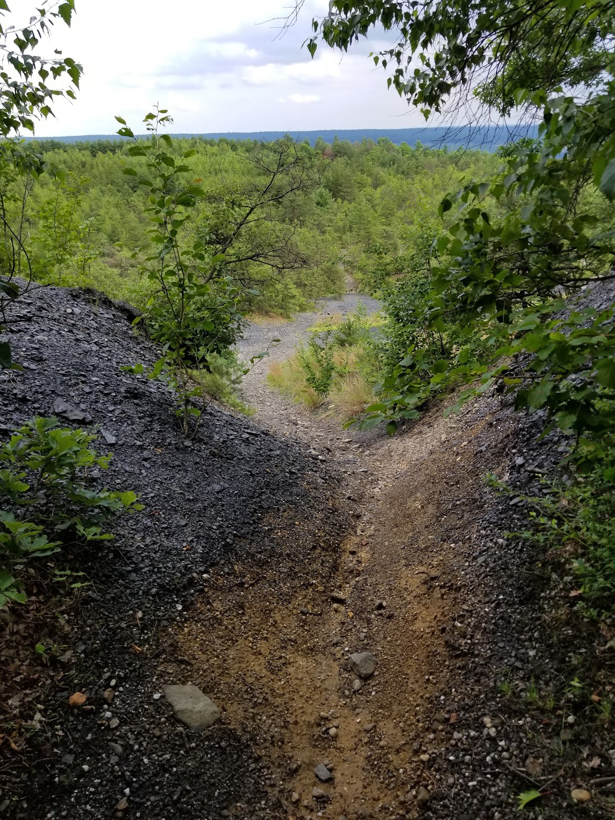
As my son, Chase, and I arrived at the huge collecting area, our expectations were more than exceeded. Nearly every piece of shale is covered in various types of plant remains, primarily ferns...it is a veritable fossil fern forest.
Here is a short video about this incredible collecting locale:
Directions: *** NOTICE: I have recently read that the current owners have closed this area for individual collecting. Please contact the owners prior to visiting the site. The latest information I have found is that the owners are Reading Anthracite. They offer permits for off-road, ATV and hiking activities, but may not allow fossil collecting.***
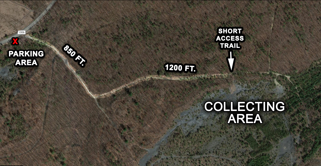
Travel to St. Clair, Pennsylvania along Route 61 (Central Eastern Pennsylvania).
If you are headed North on 61, turn right onto E. Hancock (which becomes Burma Road), if you are headed south on 61, turn left onto E. Hancock. You will drive exactly 2.8 miles and there will be a small parking area on the right just before the road curves to the left and goes uphill.
(Caution: There is another parking lot on the right just before this spot. That parking area is for a gun shooting range. If you pull into the lot and see some boulders and then several wooden stands beyond the rocks, then you are in the wrong spot...you will need to travel about another 100 yards to the east.)
Park in the small, gravel lot, and take the smooth gravel hiking trail to the southeast for approximately 850 feet. Another trail will break off to the left, take it. You will need to hike about 1200 feet down this second trail until you see a small footpath through the bushes on your right. Go about 50 feet down this trail and the collecting area will open up before you. It is quite extensive. (Don't worry, even if you miss the second trail, if you hike all the way down the first trail you will eventually hit the lower, western end of the collecting area.)